
Ecuador is a beautiful country known for its vibrant culture and stunning landscapes, but it’s also prone to natural disasters like volcanic eruptions and earthquakes. Living in such a dynamic environment means that safety and preparedness are not just considerations; they’re essential realities for everyone. If you’re unsure about how to protect yourself and your loved ones in the event of these unpredictable events, you’re not alone. This guide is here to help you navigate the critical steps needed for disaster preparedness—offering vital resources, tips, and insights into how to stay safe when nature shows her more dangerous side. Buckle up as we dive into the important information that can empower you and your community in times of need!
The Ecuador Volcanic Eruption & Earthquake Guide offers essential information on natural disaster preparedness, including crisis operations, safety recommendations, communication strategies, and the significance of volcanic hazard maps. It outlines the necessary steps individuals and communities should take to effectively prepare for and respond to both volcanic eruptions and earthquakes, ensuring public safety in regions prone to these natural hazards.
Known Volcanoes and Fault Lines in Ecuador
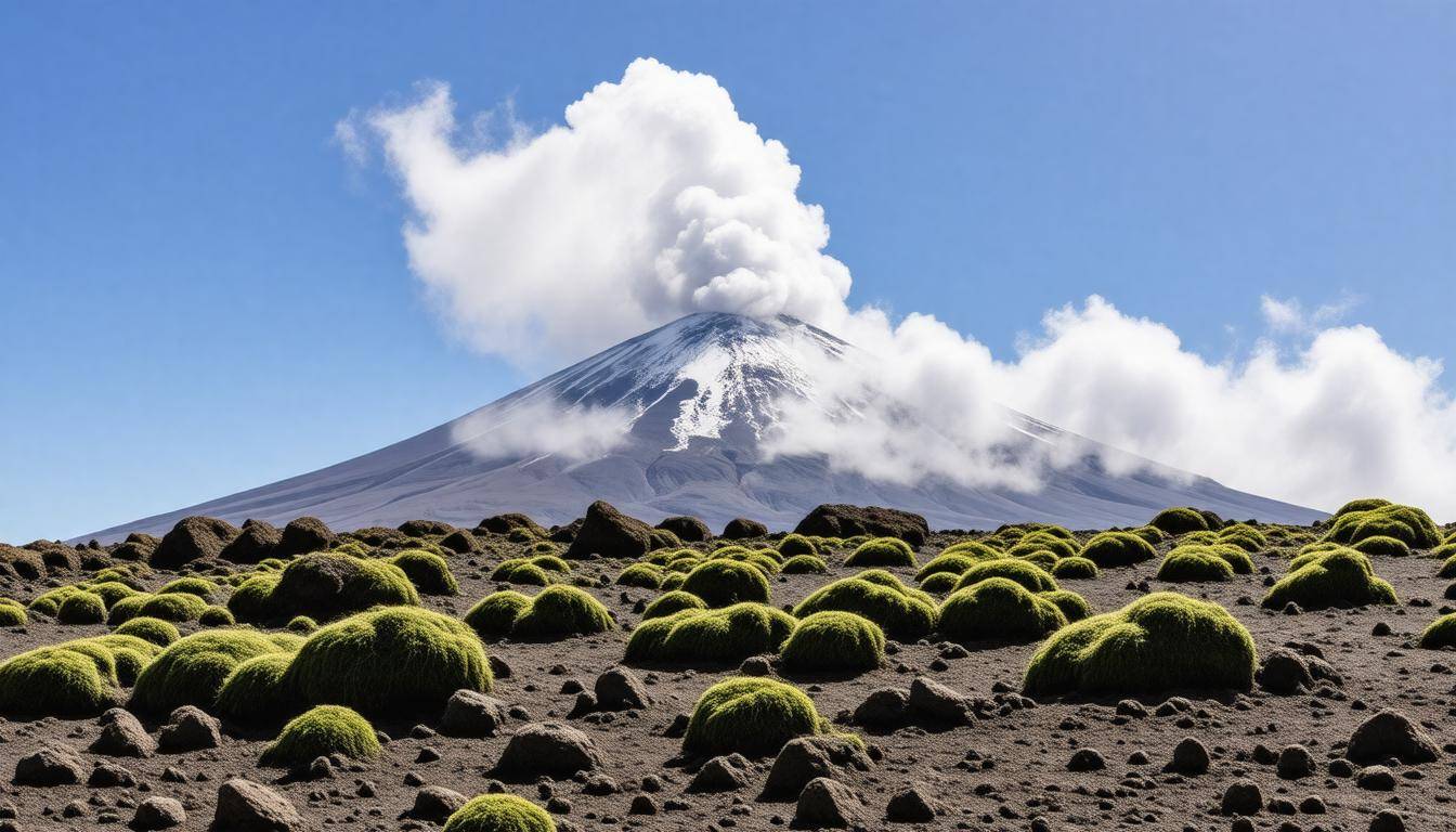
Ecuador is blessed—and challenged—by its stunningly diverse geographical features, primarily shaped by numerous active volcanoes and substantial fault lines. These volcanic structures are not just picturesque; they are potent forces of nature capable of sudden and powerful eruptions. The country harbors approximately 27 potentially active volcanoes, including iconic names like Cotopaxi, Tungurahua, and Sangay, each with its own unique history of activity and potential hazards.
Cotopaxi, standing majestically at 5,897 meters, is one of the world’s highest active volcanoes. Its reputation for danger is well-deserved; when it erupted in 2015, ash clouds soared up to 9 kilometers high, creating a spectacle that was both awe-inspiring and terrifying. Such events not only impact the immediate vicinity but can also disrupt air travel and affect health due to ash inhalation.
Monitoring these significant natural phenomena is crucial. The Institute of Geophysics works diligently to observe volcanic activity in Ecuador, providing vital risk assessments for communities living in their shadows. Because of their monitoring efforts, we remain informed about potential threats and can prepare accordingly. Understanding the implications of these eruptions means grasping the broader context of seismic activity across the country.
Major Fault Lines
Ecuador is situated on the Pacific “Ring of Fire,” known for its tectonic turmoil. This position exposes it to frequent seismic disturbances due to the subduction of the Nazca Plate beneath the South American Plate. Across this rugged terrain lie critical fault lines such as the Pallatanga and Quito faults, each having the potential to unleash devastating earthquakes.
The earthquake that struck near Muisne in 2016 serves as a grim reminder of this vulnerability. When it hit with a magnitude of 7.8, it claimed 673 lives and inflicted around $3 billion in damages.
Recognizing these geological features is essential for safety and preparedness planning. Residents located near these active faults should remain alert to warning signs associated with seismic activity and take proactive measures.
Understanding these risks lays the groundwork for developing effective safety measures tailored specifically to the circumstances of life in this vibrant yet unpredictable country. Awareness of potential threats will help inform decisions about how best to stay safe.
Recognizing Warning Signs
Understanding the warning signs of volcanic eruptions and earthquakes can significantly increase your chances of survival during an emergency. When you know what to look for, you can act quickly to protect yourself and your loved ones.
Volcanic Eruptions
One of the key indicators of a potential volcanic eruption is increased fumarole activity, which refers to the release of steam and gases from the ground. If you observe a sudden increase in this activity near a volcano, take it seriously. Additionally, watch for changes in the color of volcanic lakes; unusual color shifts can indicate rising levels of toxins or other chemical changes due to increasing geothermal activity. Moreover, an uptick in seismic activity nearby often serves as a vital warning sign that a volcano may soon erupt.
It’s fascinating to note that wildlife behavior can be an early predictor of disasters. Animals often sense impending natural crises before humans do, exhibiting unusual behaviors or fleeing areas they normally inhabit.
Earthquake Indicators
Earthquakes can also provide subtle clues before they strike. For instance, it’s not uncommon to hear low rumbling noises as tectonic plates shift beneath the surface. Sometimes you might feel minor tremors—known as foreshocks—preceding the main quake. In fact, residents near the epicenter of the 2016 Muisne earthquake experienced several smaller quakes leading up to that fateful day, offering them a brief window for preparation.
The significance of these warning signs cannot be overstated; acting promptly on them is essential. Remember that every second counts when disaster strikes. It’s also beneficial to develop a personal routine, perhaps even conducting discussions with your family about how you’ll respond if you observe any alarming signs. Reinforcing vigilance among community members ensures that everyone remains informed and prepared.
With this knowledge in hand, understanding how to monitor these crucial signs will enhance both personal safety and community resilience against imminent threats posed by nature.
Seismic Activity Monitoring

Monitoring seismic activity is not just about gathering information; it’s about safeguarding lives and property. By employing real-time data collection methods, authorities can offer timely alerts to residents, significantly reducing the risks associated with volcanic eruptions and earthquakes. This proactive approach reflects the urgent need for preparedness in a country that sits on the Pacific Ring of Fire.
Technologies in Use
Ecuador’s Geophysical Institute utilizes a variety of cutting-edge technologies to closely monitor geological activity. Among these, seismographs are crucial as they detect even the slightest ground movements, identifying tiny tremors that may indicate larger events on the horizon. Each time the earth shifts beneath us, these instruments record valuable data that helps scientists interpret seismic patterns and trends.
GPS stations play another vital role by measuring crustal deformation. As tectonic plates shift, they often cause subtle changes in earth structures. These GPS stations allow experts to visualize and analyze such deformations in real time, facilitating a clearer understanding of potential threats.
Furthermore, specialized gas emission sensors positioned around active volcanoes gather critical data regarding volcanic gases such as sulfur dioxide, which can signal rising magma levels. Collectively, these systems feed into the Threat Assessment & Gap Analysis (TAGA) platform. TAGA synthesizes all incoming data to draw conclusions about seismic threats, helping government organizations forecast potential eruptions or tremors effectively.
Public Alerts
Once this detailed data collection begins, timely public communication becomes indispensable. Citizens are encouraged to subscribe to various warning systems provided by local authorities and international organizations like the US Geological Survey. In today’s interconnected world, receiving immediate warnings can be a matter of life and death.
“Receiving timely alerts allowed us to evacuate safely during the Cotopaxi eruption,” recounts Maria, a resident of Latacunga who experienced the urgency first-hand. Her experience underscores how essential it is for individuals and families to stay informed about local emergency systems that can guide their actions during a crisis.
Yet being aware of seismic activity is only part of being prepared; it’s vital that residents take actionable steps based on this information, particularly when facing possible volcanic eruptions or significant earthquake events. Our next focus will be on essential strategies for readiness against these natural hazards.
Preparing for Volcanic Eruptions
Preparation can significantly mitigate the impact of a volcanic eruption, allowing you and your loved ones to safeguard yourselves against nature’s fury. One fundamental step in this preparation process is creating an emergency kit. It should include essentials like non-perishable foods, water—aim for at least one gallon per person per day for three days—masks, goggles, flashlights, batteries, and important documents, including any necessary medical information.
Utilizing commercial N95 masks is particularly useful as they can filter out harmful ash particles that may infiltrate the air during an eruption. This isn’t just about packing supplies; it’s about creating security—a safety net that encourages peace of mind.
Now that you’ve secured an emergency kit, it becomes imperative to establish a communication plan with your family members.
Step I – Create an Emergency Kit
Having a pre-determined meeting point is a vital part of this plan. Such a location should be easy to access and safe from volcanic hazards. Communication during emergencies can become chaotic; therefore, ensuring everyone knows how to reach each other can provide solace amid the uncertainty inherent in such situations. Families often find themselves separated when panic strikes, underscoring the importance of these plans.
Equally important as having a communication strategy is knowing your evacuation routes.
Step II – Establish a Communication Plan
Familiarize yourself with local evacuation routes and designate multiple exits from both your home and neighborhood. Understanding these paths ensures that you can swiftly move to safety when necessary. It’s not just about knowing which roads might lead you away from danger but also being aware of alternative routes in case some become blocked or unsafe during an event. Practice doing drills with your family so that everyone knows what to do—not just where to go but how to react to updates from authorities about changes in conditions.
While preparation for volcanic eruptions is vital, readiness for earthquakes is equally essential.
Step III – Know Evacuation Routes
Considering Ecuador’s geological location means understanding that both volcanic eruptions and earthquakes can occur without much warning. Keeping an updated map of local routes at hand along with regular discussions about how to respond during such events will better equip your family when those moments arise. Remember to also pay attention to alerts from local authorities regarding seismic activity; remaining informed is a key component of preparedness as well.
When you take steps today towards preparation for tomorrow’s uncertainties, you aren’t just safeguarding possessions—you are protecting lives and fostering resilience within your community.
Investing time in understanding these components and committing to continuous practice and review creates a safer environment for yourself and those around you.
With these strategies in place, you’ll be well-prepared as we turn our focus toward additional practical tips for earthquake readiness that every household should embrace.
Earthquake Preparedness Tips
Earthquakes often strike unexpectedly, so having a plan can make all the difference when the ground begins to tremble beneath you. One of the most crucial aspects of preparedness starts at home. For instance, securing heavy furniture and appliances to walls is an essential step; it mitigates the risk of these items toppling over during a quake. It’s best to avoid placing heavy objects above beds or sofas because if they fall, they could cause serious injury.
However, it’s not just about anchoring items down; knowing how to respond is equally important.
In the event of an earthquake, you should drop to the ground immediately, taking cover under durable furniture such as a sturdy table or desk. This simple act can protect you from falling debris and keep you safe until the shaking subsides. Remember to hold on firmly to your shelter—don’t let go until the trembling has passed. Furthermore, stay clear of windows or large glass fixtures that might shatter, cutting you or causing additional hazards.
As your awareness grows for indoor safety, consider how to navigate public spaces effectively.
When you find yourself outdoors during an earthquake, move swiftly to an open area away from buildings, trees, streetlights, and utility wires. These structures pose potential risks of collapsing or dropping during seismic activity. A noteworthy lesson from the 2016 earthquake highlighted this danger: outdoor markets and plazas often become crowded places where people gather; however, these are exactly the areas you want to avoid when disaster strikes. Staying in open fields or designated safe zones can keep you safer than crowding into bustling centers.
Developing a robust emergency evacuation plan is essential. Designate a meeting place for your family in case you become separated during a quake. This should be somewhere recognizable that everyone can easily remember, such as a local park or school yard. Ensure all family members understand how to reach this spot from various locations.
It’s also wise to practice your emergency response drills regularly with your family so that everyone knows their role and responsibilities when an earthquake occurs. Being prepared can minimize panic and confusion during actual events.
Finally, no preparedness plan is complete without stocking up on emergency supplies that can sustain you in dire situations.
An emergency kit should include essentials like water (one gallon per person per day for at least three days), non-perishable food (for at least three days), a flashlight with extra batteries, a first aid kit, and a whistle for signaling help if needed. Having these supplies ready ensures that your household can respond swiftly following an earthquake without scrambling for basic necessities.
Understanding how to prepare both inside your home and in public spaces significantly heightens your safety in the event of an earthquake. Maintaining this level of readiness contributes greatly to your overall disaster preparedness strategy as we look into how families can act efficiently during evacuation scenarios.
Emergency Evacuation Plans
Creating an effective evacuation plan is essential for any household, especially in a region that faces the threats of volcanic eruptions and earthquakes like Ecuador. This process starts with assessing potential risks in your area, understanding the characteristics of your household, and determining the quickest routes to safety. Each family member must be involved in this planning process so that when the time comes, decisions can be made quickly without confusion or fear.
Creating an Evacuation Plan
Crafting your evacuation plan involves several critical steps, and it should consider the specific nature of natural disasters likely to occur. To begin with, it’s beneficial to have a clear understanding of your surroundings. For instance, if you live in an area prone to volcanic eruptions, knowing where higher ground is crucial can save lives in minutes. Conversely, during earthquakes, it’s vital to identify open spaces away from buildings and other potential hazards. Recognizing these zones can be done easily using resources like Google Maps or local emergency management websites.
It’s equally important to familiarize yourself with all available escape routes from your home. Consider drawing a simple map that outlines these safe zones, marking paths clearly so everyone knows where to go without hesitation during an emergency situation. Encouraging children to engage in this mapping process can help them feel more secure as they understand their surroundings better.
Step I – Map Out Safe Zones
Identifying safe zones is not merely about where to go but also how to get there swiftly and efficiently. If you have elderly family members or young children, it’s essential to account for their needs when planning your route. Safe zones may also include community shelters designated by local authorities, so check whether such facilities exist nearby and keep their locations noted within your evacuation plan.
Regularly review these safe zones with your family to address any changes in the layout of your neighborhood or new construction that could impact your route. These simple updates can make a significant difference when time is of the essence.
Step II – Practice Drills
Practicing evacuation drills should become a routine for every household as it builds muscle memory. A simulation can be straightforward—just act as if an earthquake or eruption were happening while timing how long it takes everyone to reach safety.
Research indicates that families who routinely practice these drills enhance their preparedness significantly; they actually reduce reaction times by 50%. Just think about it: when faced with panic, doing something you’ve practiced feels much more manageable than trying to figure things out on the fly.
Incorporate various scenarios into these drills too—whether you’re all together at home or one person is at school, another at work—it’s necessary for everyone to understand what they would do in each situation increasingly strengthens both physical preparedness and emotional resilience within the family unit.
Moreover, having an established communication plan is equally critical as we think about the best ways to stay connected during chaotic moments when every second counts.
Health and Safety Precautions
The risks to our health increase significantly during volcanic eruptions and earthquakes, making health and safety precautions vital. Understanding these risks allows you to take proactive measures that can safeguard your well-being.
One of the most pressing issues during a volcanic eruption is air quality. Volcanic ash can compromise the air we breathe, potentially leading to respiratory complications that are both immediate and long-term. This is where wearing masks becomes essential; using N95 respirators or similar masks can effectively filter out harmful particles. After all, nobody wants to contend with the repercussions of prolonged exposure to ash, which can cause silicosis—a debilitating lung disease.
The importance of wearable protection cannot be overstated, as breathing clean air becomes an absolute necessity during eruptions.
Following eruptions or seismic activity, access to clean water is another critical consideration. Earthquakes often damage municipal water supply lines, increasing the risk of contamination. Herein lies the necessity for a stockpile of bottled water as part of your emergency preparedness plan. As Pedro, a survivor from Manta, recounts, “We relied solely on our emergency water supply for weeks following the earthquake,” emphasizing how crucial it is to ensure your water supplies are in order before disaster strikes.
It’s not enough to only think about what happens immediately; having a well-thought-out plan in place makes a world of difference when faced with uncertainties following catastrophic events.
Furthermore, consider keeping other health-related items on hand in your emergency kit. Essential medications and first aid supplies should be prioritized, as any disruption in treating common ailments could exacerbate stress during crises. Health precautions extend beyond just physical safety; they encompass emotional well-being too. The psychological ramifications of living through such traumatic experiences can last far longer than the physical danger itself.
Therefore, understanding mental health resources and support systems in your area can serve as an invaluable resource post-disaster.
By taking these health precautions seriously and preparing fully for potential dangers, you not only protect your immediate well-being but also position yourself for a smoother path to recovery when conditions stabilize. Transitioning from immediate needs leads us into the broader effects on communities that endure such disasters.
Long-term Impacts on Communities

Natural disasters don’t just cause immediate damage; they instigate a cascade of long-term consequences that affect every aspect of community life. After the 2016 earthquake in Ecuador, many communities faced stark realities extending far beyond the disaster day. The emotional toll, financial strains, and shifts in social dynamics have left deep imprints, some still being felt today.
Economic Impact
The earthquake, registering a magnitude of 7.8, led to estimated economic losses upwards of $3 billion. This staggering amount reflects not only physical destruction—like collapsed buildings and damaged roads—but also represents a significant setback in local economies. As businesses closed or operated at reduced capacity, essential public services suffered too.
Imagine a school struggling without proper facilities or a hospital barely able to function due to structural damage—such scenarios illustrate how intertwined our systems truly are.
Rebuilding efforts go beyond fixing what was broken; they require substantial resources and prolonged attention. With funds directed toward restoration, other critical services may find themselves underfunded. For instance, while roads might be prioritized, community health programs could suffer neglect during recovery.
Social Impact
“Our town hasn’t been the same since the quake; people left but they have not returned,” reflects a resident from Manabí on the changes following the earthquake. Such personal accounts reveal how deeply rooted human connections can fracture when families are displaced or businesses shutter indefinitely. The departure of community members removes faces from neighborhoods and disrupts established social networks fostering support, resilience, and shared culture.
Displacement has cascading effects that can increase emotional and psychological stress among survivors—issues like anxiety and depression become prominent as communities struggle to adapt without their foundational structures. Without regular interaction with familiar friends and neighbors, the sense of belonging diminishes. Children especially face challenges adjusting to new schools and social circles after being uprooted.
A community thrives on its relationships; therefore, rebuilding these connections should be as much a part of recovery efforts as restoring physical infrastructure.
While the scars left by natural disasters are undeniable, there remains hope and space for healing through intentional efforts focused on fostering resilience within communities.
We must remember that every small step taken towards rebuilding both physically and emotionally contributes to creating stronger communities capable of weathering future storms. Together, we can restore hope for all affected.
What steps should I take to prepare my family for a volcanic eruption or earthquake in Ecuador?
To prepare your family for a volcanic eruption or earthquake in Ecuador, create an emergency kit containing essential supplies such as water, non-perishable food, first-aid materials, and flashlights. Establish a communication plan to ensure everyone knows how to contact each other during an emergency. Familiarize your family with evacuation routes and designated meeting points, as studies show that having a family emergency plan can significantly reduce response time during disasters. Lastly, stay informed about local volcanic activity and earthquake alerts through reliable sources. Remember, approximately 80% of Ecuador’s population lives in areas affected by geological hazards; therefore, preparedness is crucial for safety.
What resources are available for real-time updates during a volcanic eruption or earthquake in Ecuador?
During a volcanic eruption or earthquake in Ecuador, resources such as the Instituto Geofísico (IG) provide real-time updates through their website and social media channels. The National Emergency Operations Committee (COE) also disseminates critical information and alerts through local media and mobile applications. Additionally, the Ecuadorian government recommends following alerts from regional emergency services, which can be vital, especially considering that Ecuador experiences tectonic activity frequently—recording over 5,000 earthquakes annually. Staying informed through these platforms is essential for safety and preparedness.
How do scientists monitor volcanic activity and seismic movements in Ecuador?
Scientists in Ecuador monitor volcanic activity and seismic movements using a combination of seismographs, GPS stations, and satellite imagery. These tools allow for real-time tracking of ground deformation and seismic events. For example, the Instituto Geofísico de Ecuador operates over 50 seismic stations nationwide, providing crucial data on the country’s active volcanoes like Cotopaxi and Sangay. By analyzing this data, scientists can detect early warning signs of eruptions or earthquakes, enhancing public safety efforts in a region known for its geological volatility.
What historical examples of volcanic eruptions and earthquakes have significantly impacted Ecuador, and what lessons were learned from them?
Ecuador has experienced significant volcanic eruptions such as the 2003 eruption of the Sangay volcano and the 1999 eruption of the Cotopaxi volcano, both of which caused widespread disruption and highlighted the need for improved monitoring systems. The devastating 1949 earthquake in Ambato, which resulted in approximately 5,000 deaths, underscored the importance of earthquake-resistant infrastructure and community preparedness. Lessons learned include implementing early warning systems and strengthening building codes to reduce vulnerability, ultimately aiming to save lives and mitigate damage during future natural disasters.
Are there specific regions in Ecuador that are most at risk for volcanic activity and earthquakes?
Yes, specific regions in Ecuador are particularly at risk for volcanic activity and earthquakes, primarily due to the country’s location along the Pacific Ring of Fire. The Andes mountain range, which runs through Ecuador, is home to several active volcanoes such as Cotopaxi and Chimborazo. The southern and central parts of the country, including provinces like Tungurahua and Pichincha, experience higher seismic activity. Statistics indicate that Ecuador has an average of over 100 earthquakes per year, with significant events occurring every few years, highlighting the need for heightened awareness and preparedness in these vulnerable areas.